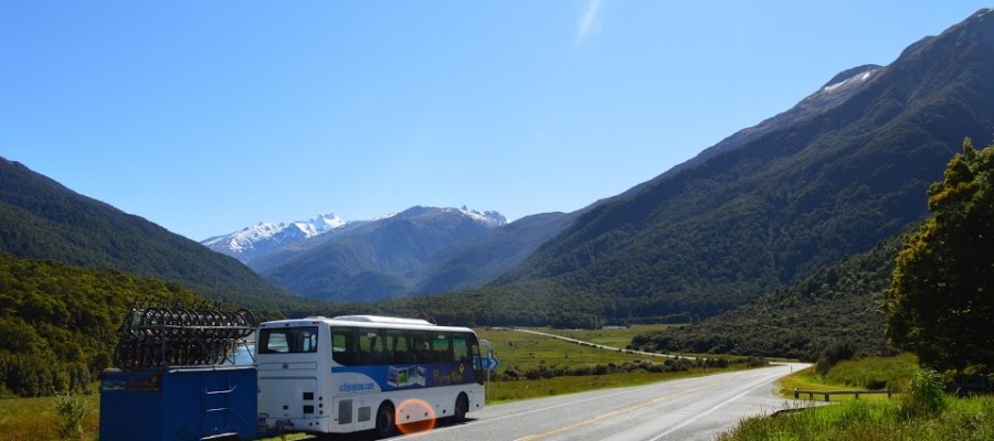
New Zealand is quite a small country however because it's so mountainous and rugged it does take quite a long time to travel around so we do travel in the bus most days but this shouldn't be a negative aspect of your trip. We have built the tour itinerary up over the years to take you to the best places in the country but you're also going to see a lot of awesome scenery just by looking out the window.
Travelling by bus will also give you an opportunity to see how diverse the landscapes really are here and also how fast the features of this amazing landscape can change from place to place. You're going to be passing mountains and lakes, then heading to the sea and temperate rain forest. You'll pass active volcanoes before travelling through open farmland, the New Zealand roads are a testament to the kiwi spirit and resilience as people have battled for hundreds of years to tame the landscape and shape the country.
In this article we have narrowed it down to our top 6 roads we love to drive, we look forward to showing you them when you come on a trip with us!

Desert Road - North Island
This road is part of New Zealand's longest highway, State Highway 1, that spans the North and South Island. Through the middle of North Island you'll come across a barren wilderness area known as the Rangipo Desert.
This environment is not a desert because of lack of rainfall but because there is poor soil here along with strong drying winds. The desert covers a large area surrounding the volcanic peaks of Ruapehu, Tongariro and Ngauruahoe in the central volcanic plateau. The volcanic history of this area has also added to the land here becoming infertile as past volcanic eruptions have effectively destroyed all the seeds from a variety of plant species that may have grown here previously.
As the land is more or less unusable for farming and the area has severe winter weather which sometimes closes the road it is mostly uninhabited which means on a clear day you can get some great views of the Tongariro National Park. The Rangipo desert is used by the New Zealand armed forces as a training ground and it was also used as a film set for Mordor in Lord of the Rings.
During our North Island tour we travel through the Rangipo Desert after you have completed the famous Tongariro Crossing giving you a last chance to view this awesome National Park before making our way further south.

Coromandel Peninsula - North Island
The roads of the Coromandel are steep and twisty but there are awesome views and beautiful forests around every corner. The Coromandel area is only a few hours drive from Auckland and even closer to Hamilton so it's a popular destination for locals as well as tourists from overseas. The area has incredible white sandy beaches, dense forest perfect for hiking and is filled with a rich history of Maori settlement to European logging and mining operations.
State Highways 25 and 25A form a loop around the peninsula and take you past most of the major settlements and sights. The peninsula is volcanic in origin and there is remnants of this in the landscape such as the steep sided mountains which the road traverses making driving conditions challenging. Added to the steepness of the roads is the changeable weather conditions. Like much of New Zealand the weather can be hard to predict and throughout the year a large amount of rainfall can suddenly accumulate causing slips that block the roads and make block off some smaller communities. Usually the roads don't get closed for long but it's wise to know the forecast when travelling out to the Coromandel.
During our tour we take you up and over the Coromandel's forested interior and over to the beautiful beaches of Hahei and Hot Water Beach before visiting the historic gold mining town of Waihi and the Karangahake Gorge the following day.

Coastal Road to Kaikoura - South Island
Travelling down from Picton the road cuts inland for a while before you are met with great views across the Pacific Ocean. State Highway 1 follows the coastline all the way to Kaikoura and beyond before heading back inland through the Canterbury Plains towards Christchurch. The road has the peaks of the Kaikoura ranges on one side and the beautiful pacific coast on the other. You can pull in at a seal colony before passing a handful of local surf spots and then onto Kaikoura, a bustling tourist town which has trips to view migrating whales, swims with dolphins and kayaking with fur seals.
Unfortunately this road has been closed since November 2016 as a large earthquake caused numerous slips and damage to the road cutting of all access to Kaikoura. Currently the Southern route is now open but the Northern road is yet to be completed however the re build is making good progress with the road expected to reopen at the end of this year.
Currently the southern route to Kaikoura is unfeasible for our trips and we are being rerouted through Lewis Pass and Hanmer Springs however as soon as the road re opens we hope to be able to go back to Kaikoura as this is many peoples highlight during their time in New Zealand.
Mackenzie Country - South Island
If you start heading Inland in the South Island you will most likely come across mountains! The Southern Alps is a 500km long unbroken chain of mountains that makes up a lot of the mountains in the south but there are a number of other ranges that fill out the rest. As you journey inland from the East Coast you'll see the Alps in the distance and on approach you'll pass into the boundary of Mckenzie Country, home to a wide open spaces, mountain vistas and some awesome glacial lakes.
Along the road you'll pass the incredible Lake Tekapo, a bright, turquoise blue coloured lake that gets its colour from the glacial flour suspended in the water. Glaciers up in the mountains grind rocks into a fine powder which gets washed in the lake and is reflected by sunlight giving the lake its famous blue colour. Next you come across another lake with a similar colour, Lake Pukaki, the difference this time is a the awesome views of New Zealand's highest peak, Aorkai/Mt. Cook. Continuing along the road and away from the Mckenzie region you'll pass two more lakes, Lake Ruataniwha and Lake Ohau before either continuing south towards Queenstown or back to the East coast.
On our trips we head inland making a stop in Tekapo and then staying night on the edge of Lake Pukaki with unbeatable views of Aoraki/Mt. Cook. We visit the Aoraki/Mt. Cook National Park the following day before heading back to the East Coast and making the most of our time on the Pacific.

Milford Road - South Island
Milford Sound is one of the highlights for many people on our trips. The cruise takes you through the dramatic fiord passing huge waterfalls, near vertical sea cliffs and usually some local wildlife before reaching the Tasman Sea and returning to the dock with a whole bunch of stunned passengers! The cruise is awesome but the drive in is just as dramatic and one that we love to do on each trip.
Leaving Te Anau we hit the road towards Fiordland National Park, the largest National Park in New Zealand. As soon as you enter the park you're greeted with dense native beech forest and incredible mountain views. The road takes you through the vast Eglinton valley where we'll make a photo stop before continuing on to Mirror Lakes, another short stop for us to look at the small ponds that reflect the mountains in the backdrop on a clear calm day. After these short stops it's on to our camp at the historic Gunns Camp.
Our camp this night is situated in the middle of the Hollyford valley and is filled with history as the owners of the camp have tried to preserve its past. The camp was once used by a group of workers in the 1930's who were here trying to build a road from Te Anau all the way to Haast on the West Coast. The road was never actually completed but the camp still remains as a testament to those workers who braved harsh conditions and lived out here among the sand flies.
The following day we leave Gunns camp and travel to Milford Sound. This is where the road gets really interesting as we make our way up to the Homer Tunnel. This huge 1.2km long tunnel burrows underneath the Durran mountain range before coming out in the Cleddau Valley. This tunnel was started by work crews in the 1930's but wasn't completed until 1953. Again workers faced harsh conditions, avalanche risk and flooding but eventually they made it through.
The Tunnel has a gradient of about 1:10 so it's pretty steep and the road doesn't let up for a while as we make our way down from 945m elevation at the start of the Homer Tunnel down to Milford Sound at sea level. On route we'll stop in for a short walk to 'the chasm', a series of waterfalls that have collected small rocks and carved out interesting rock formations. Finally we arrive at Milford Sound for our memorable crews as the views and stunning scenery continue into the afternoon.
After the cruise we have to drive all the way back the same way we came in on our return to Te Anau, awesome! Jump on one of our tours in the South Island and we'll take you on this epic trip into Milford Sound, one of our most memorable destinations.

West Coast Road - South Island
The West Coast of New Zealand is a special place famous for a its rugged coastline, temperate rain forest and the glaciers that flow down from the Southern Alps. These are just some of the reason why our guides love to travel this beautiful part of the country.
The West Coast road is twisty and steep in places and is famous for its one-lane bridges that pop up every now and then to keep you on your toes but the scenery is undoubtedly some of the most spectacular in New Zealand helped by the fact that this area is generally quite underpopulated. This also helps the driving conditions as most of the people driving this road will be other tourists and local farmers going from field to field.
We drive north travelling up the coast starting in Haast and making our way towards Westport before we head back inland through the Buller Gorge. One of bigger days on the road actually starts in the more inland area of Lake Wanaka and we start by traversing the Haast pass to connect with the West Coast, already dramatic this mountain pass is just the beginning of our drive. Once on the coast we stop off to do a couple of short walks at Shipcreek where it's possible to spot Hector Dolphins playing in the waves before we continue on passing dense forest and get reunited with views of the Southern Alps as we arrive in Fox Glacier Township.
After a day exploring Fox Glacier it's back on the road as we twist and turn over a section of road known as the three valley before reaching Franz Josef. A quick resupply here and we head to one of our favourite camps, Okarito. A picturesque and historic town on the coast where we usually enjoy a fire down on the beach.
It's important to note here that so far the everything we drive through from Lake Wanaka all the way to Okarito is part of the incredible Te Wai Pounamu/South West New Zealand World Heritage area. This massive area is recognised by UNESCO for its outstanding natural beauty and is a stronghold for many native plants and wildlife. It encompasses 10% of New Zealand's total landmass but is home to only 1% of its population plus it is includes 4 different national parks: West land Tai Poutini, Aoraki/Mount Cook, Mount Aspiring and Fiordland.
As we continue up this epic coast road we pass the two largest towns of Hokitika and Greymouth. Hokitika is a small town that is famous for its greenstone shops and other local craft and each year holds a wild foods festival where you can try some interesting bush cuisine. Greymouth is the largest town on the coast and is the major service area for local farms, forestry and mining operations.
Leaving Greymouth you'll start what is known as the 'Great Coast Road'. Voted as one of the top 10 coastal roads in the world by Lonely Planet we drive from Greymouth through to Punakaiki where we'll be staying the night giving you the best opportunity to explore the incredible Paparoa National Park. This National Park is home to towering limestone sea cliffs, dense native forest and the Nikau Palm tree, the worlds most southern plam tree species.
After visiting Punakaiki we will be driving the last bit of the coast on route to the top of the South Island taking in the last of the epic coastal views before heading inland through the Buller Gorge. It's quite an experience travelling the coast and one we hope you won't miss. To see the best the coast has to offer hop on on of our tours and we can show you all the best places as we make our way along one of New Zealand's most spectacular roads!